HERBAL URBANISM: BEITOU 2. VERTICALl CITY
Curated by Manray HSU
|
To imagine a city by marking an area on a plane surface is often the very first step to misunderstand what it is today. As a symbol of human civilisation, the city consists not only of various human-made infrastructure, but also of million-year formations of rock, hydrological landscape, and the lives of other species within and without its scope. The city is located at some place or region, but its life goes beyond the limits of its administration and the country, of which it is part. The city lives on globally widespread and intricately connected network systems. Together, these systems act not so much like a large web horizontally covering the planet surface, as interconnected volumes stretching vertically around our planet: “From 10,000 metres below the sea, to 35,000 kilometers in orbit above the surface of the earth, the infrastructure that supports urban life has reached unimaginable extents below ground, in the water, and across outer space.”* Complex engineerings to extract subterranean fuel and resources, pipelines laid down on the deep ocean to transport gas and oil, submarine communications cables, across different countries and continents, or large amount of waste dumping on far away, disadvantaged area, buildings stacked up on top of each other, and signals from satellites orbiting the planet — all these interconnected, visible and invisible, systems make modern cities vertical, to replace the horizontal landscape that has dominated human geography since the colonial eras. Hence the arrival of what Eval Weizman called “the vertical 3D sovereignty” which now inevitably occupies the central stage of human civilisation.
Art provides us with an access to comprehend the related changes in perception and in the way we live. As a production of the city, we moderns are in a process of aesthetic transformations while verticality unfolds. We constantly experience the urban verticality through mass media and such representational specifics as documentary films. With the overturn of technology, the old, linear world view is being subverted. At a time when our visual system is increasingly dominated by Google Maps, or the so-called bird’s-eye-view and panorama perspectives, our body’s relationship to the environment undergoes a fundamental shift. Since the |
mid-nineteenth century, camera has been combined with such aviation vehicles as hot air balloon and plane. From its early usage during the First World War to survey and define what is to be protected and destroyed, to today’s multifaceted functions in transportation, hydraulic engineering, environmental protection, urban planning, archaeology, personal entertainment, etc., aerial photography has also become tools of artistic expression and activist resistance. For artists and activists, it opens up new possibilities to visualise, reflect on and respond to the urban system and its ecology. Once the old, horizontal and stable perspective is overcome, the multi-focal and non-linear perspective now redefines our spatial visions and bodily experiences as well as the imagination of what the world is.
“Herbal Urbanism: Beitou, Part 2” features two works using drone as a means to explore and intervene into the spatiality of the city and as an attempt to reflect on the co-existence of nature and humans. Jui-Kuang CHAO, an artist/activist based in Tainan, extends his body with drone as his doppelganer to open up aerial visual possibilities. In the work of video and photographs, “The Beautiful Longqi Moonworld,” this extended body aviates through the badlands named Longqi Niupu Mudstone Park that the government plans to turn into a polluted waste landfill. As the viewer navigates the magnificent landscape, with its rich bio-diversity and geologic layers, the fear of man-made pollution and destruction looms. Another work by CHAO is a series of photographs titled “The soil is a mirror,” in which the artist documented in different phases how industrial waste was secretly dumped in the farmland. Nicely composed with geometric colour-fields, these landscape photographs echo modernist abstract paintings, while realistically representing illegal waste dump in fish farms and rice-paddies. The drone’s aerial vision reveals the limits of traditional means of representation and transmission, and thereby short-circuits the flow of false information. “Mirror” in the title, furthermore, references to one of the themes of Anthropocece: as we broaden the temporal-spatial scope of vision (aerial perspective of verticality in this work), we would be able to see on the land a reflection of human traces in large scale. |
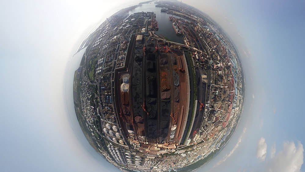
FENG Wei-Chung , an artist based in Taizhong, uses drone equipped with 360 degrees panorama technique to document the landscape of Taiwan’s east and west coastlines, revealing a vast contrast between them due to long-term human intervention. The six photographs show an industrial landscape in the west coast versus a pristine natural landscape in the east. The exhibition space is installed with a VR headset which the visitor can wear to view the landscape and move around to simulate the drone-view in the air. Whatever appears in the visitor’s view is projected unto the screen so that other visitors can see the same view. Thus two different views are experienced: one is of the VR wearer whose first-person 3D vision is virtually connected to the drone-body, and the other is of those seeing the 2D representation of that vision on the projection screen. This mixture of 3D experience with 2D representation has become a main vision in the development of urban verticality. As human society endeavours to reconfigure its kin to nature, to other species, and landscape as well as cultural space, the mixed vision of the vertical will be the key to this new relationship. In FENG’s exhibition space, the 360 degree VR experience also contrasts with those photographs on the wall in a fundamental way: whereas the former offers a floating, non-linear, safe yet unstable drone-body experience, the latter “condenses” the 360 degree panorama into a spherical vision, in which the image expands from the centre to the distorted margins, intimating a microcosm existing in an unknown, chaotic macrocosm. *Pierre Belanger, Altitudes of urbanization, 2016 (Tunnelling and Underground Space Technology)
Herbal Urbanism: Beitou is organised in collaboration with the Honggah Museum, affiliated with and co-funded by Topography of Mirror Cities. The Topography of Mirror Cities project, featuring in Dhaka, Bangkok, Taipei, Jakarta, Kuala Lumpur and Phnom Penh, is conducted by Sandy Hsiu-chih Lo as chief curator, and funded by the National Culture and Arts Foundation, Taiwan. Special thanks go to the Honggah Museum and Sandy LO Hsiu-Chih. |
ARTIST

PUBLICATION